Back to Weather

5-day forecast / Sherman, TX

TodayMostly Cloudy0° / 75° 3%
SaturdayMostly Sunny92° / 74° 4%
SundayChance Showers And Thunderstorms then Showers And Thunderstorms Likely83° / 65° 71%
MondayShowers And Thunderstorms Likely77° / 63° 68%
TuesdayMostly Sunny84° / 71° 3%

Flood Watch in Effect for Sherman as Storms Approach

Sherman skies, every four hours — clear, local, and weather you can trust.

A severe Flood Watch is active for Sherman, TX, as thunderstorms bring heavy rain risks today. Temperatures will climb toward 88F tomorrow with extreme heat indices.

Carmen Solis

June 7, 20262 min read

National Weather Service radar for North Texas (KFWS)

Active Alerts and Current Conditions

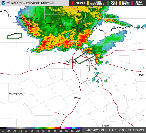
A severe Flood Watch is currently in effect for Sherman, Texas, issued by the National Weather Service in Fort Worth. This alert remains active until 4:00 PM CDT today, signaling a significant risk for flooding due to heavy rainfall. Residents should monitor conditions closely as the day progresses.

As of this Sunday morning, the air temperature stands at 71F, with a feels-like temperature of 74F. Humidity is high at 92%, with a dew point of 69F. Winds are blowing from the south at 12 mph, with gusts reaching up to 24 mph. The sky is currently partly cloudy.

Today’s Forecast and Storm Risk

Thunderstorms are expected to develop today, with a 67% chance of precipitation. According to the National Weather Service, showers and thunderstorms are likely before 1pm, followed by a chance of showers and thunderstorms later in the day. The sky will be mostly cloudy, with a high near 84F. Heat index values may reach as high as 99. South winds will persist at 10 to 15 mph. New rainfall amounts between a tenth and quarter of an inch are possible. Tonight, there is a slight chance of showers and thunderstorms before 7pm. The low will be near 68F, though the National Weather Service indicates a low around 75F. Heat index values could reach 97. Winds will continue from the south at 10 to 15 mph, with gusts as high as 25 mph. The chance of precipitation drops to 20% tonight.

Tomorrow and Safety Reminders

Tomorrow, the weather will clear up significantly. The high will be near 88F, with a low near 75F. The chance of precipitation drops to just 2%, though thunderstorms are still listed in the forecast data. The sky will be partly sunny. Heat index values are expected to climb as high as 105. South winds will remain at 10 to 15 mph, with gusts up to 25 mph. Monday night will be clear, with a low around 75F and heat index values up to 103.

Given the active Flood Watch, please avoid driving through flooded roadways. As temperatures rise toward the upper 80s and heat indices approach 100F, stay hydrated and limit prolonged outdoor exertion during the hottest parts of the day. Check on neighbors who may be vulnerable to extreme heat or flooding risks.

National Weather Service radar for North Texas (KFWS)

Sources

https://radar.weather.gov

https://api.weather.gov

https://open-meteo.com

Share

Carmen Solis

Carmen Solis covers weather, the environment, and outdoor life around Sherman.

Related Stories