Back to Weather

5-day forecast / Sherman, TX

TodayMostly Cloudy0° / 75° 3%
SaturdayMostly Sunny92° / 74° 4%
SundayChance Showers And Thunderstorms then Showers And Thunderstorms Likely83° / 65° 71%
MondayShowers And Thunderstorms Likely77° / 63° 68%
TuesdayMostly Sunny84° / 71° 3%

Flood Watch in Effect for Sherman as Humidity and Rain Persist

Sherman skies, every four hours — clear, local, and weather you can trust.

A severe Flood Watch is active for Sherman, TX, through tomorrow afternoon. High humidity and persistent rain chances dominate the forecast for today and tomorrow.

Carmen Solis

June 6, 20262 min read

National Weather Service radar for North Texas (KFWS)

Active Alerts and Current Conditions

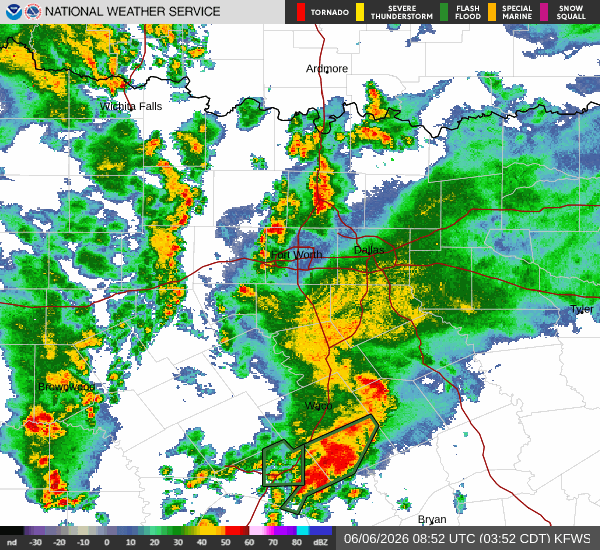
A severe Flood Watch is currently in effect for Sherman, Texas. This alert was issued by the National Weather Service in Fort Worth and remains valid until 4:00 PM CDT on June 7. Residents should remain vigilant as conditions are favorable for flooding.

It is currently Saturday overnight in Sherman. The air temperature stands at 73F, with a feels-like temperature of 77F. Humidity is quite high, with the relative humidity at 90% and a dew point of 70F. Winds are blowing from the south-southeast at 9 mph, with gusts reaching up to 18 mph. The sky remains overcast.

Forecast for Today and Tomorrow

Overnight, showers and thunderstorms are likely. Clouds will persist with a low around 71F. South-southeast winds will drop to around 5 mph. There is a 70% chance of precipitation, with new rainfall amounts between a quarter and half of an inch possible.

Today, showers and thunderstorms are likely before 4 PM, followed by a chance of showers and thunderstorms later. Expect mostly cloudy skies with a high near 86F and a low near 73F. The chance of precipitation is 38%, with dense drizzle noted. New rainfall amounts between three quarters and one inch are possible.

Tomorrow, the threat of rain continues. Highs will reach near 86F, with lows dropping to around 70F. The chance of precipitation rises to 59%, with thunderstorms expected. Winds will increase to around 10 mph from the south, with gusts as high as 20 mph. A chance of showers and thunderstorms is possible before 7 AM, followed by showers and thunderstorms between 7 AM and 4 PM, and a chance of showers and thunderstorms later. New rainfall amounts between a quarter and half of an inch are possible.

Safety Reminder

With the active Flood Watch and high humidity, please stay informed about local weather updates. Avoid driving through flooded roadways, and secure outdoor items that could be damaged by wind or heavy rain. Stay safe and monitor conditions closely.

National Weather Service radar for North Texas (KFWS)

Sources

https://radar.weather.gov

https://api.weather.gov

https://open-meteo.com

Share

Carmen Solis

Carmen Solis covers weather, the environment, and outdoor life around Sherman.

Related Stories