Back to Weather

5-day forecast / Sherman, TX

TodayMostly Cloudy0° / 75° 3%
SaturdayMostly Sunny92° / 74° 4%
SundayChance Showers And Thunderstorms then Showers And Thunderstorms Likely83° / 65° 71%
MondayShowers And Thunderstorms Likely77° / 63° 68%
TuesdayMostly Sunny84° / 71° 3%

Flood Watch in Effect for Sherman as Humidity and Rain Persist

Sherman skies, every four hours — clear, local, and weather you can trust.

A severe Flood Watch is active for Sherman, TX, alongside high humidity and a chance of rain today and thunderstorms tomorrow.

Carmen Solis

June 6, 20262 min read

National Weather Service radar for North Texas (KFWS)

Current Conditions and Alert Status

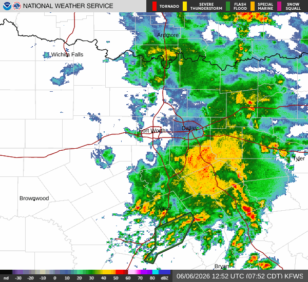
A Flood Watch with severe severity and future urgency is currently in effect for Sherman, Texas. This alert was issued by the National Weather Service in Fort Worth and remains active until June 7 at 4:00 PM CDT. Residents should remain aware of the potential for flooding as conditions evolve.

Right now, the air is quite heavy with moisture. The current air temperature sits at 74F, but the heat index makes it feel like 79F. Relative humidity is at 91%, with a dew point of 72F, creating a muggy atmosphere. Winds are blowing from the south southeast at 10 mph, with gusts reaching up to 16 mph. The sky is completely overcast, blocking out direct sunlight.

Today and Tonight Forecast

Today, showers and thunderstorms are expected before 1pm, followed by a chance of showers and thunderstorms later in the day. The sky will remain mostly cloudy. The high will reach near 86F, while the low will drop to near 73F. There is a 69% chance of precipitation, with light rain likely. New rainfall amounts between a quarter and half of an inch are possible.

Tonight, the chance of showers and thunderstorms continues before 1am, then again between 1am and 4am, before persisting as a general chance. Temperatures will start around 71 and rise to around 73 overnight. The low will settle near 70F. Winds will shift to the south at around 5 mph. There is a 50% chance of precipitation, with new rainfall amounts between a half and three quarters of an inch possible.

Tomorrow Outlook

Tomorrow, the pattern shifts slightly with a chance of showers and thunderstorms before 7am, followed by showers and thunderstorms between 7am and 4pm, and then a chance of showers and thunderstorms later. The high will be near 86F, with temperatures falling to around 84 in the afternoon. Winds will increase to the south at around 10 mph, with gusts as high as 20 mph. The chance of precipitation is 80%, with new rainfall amounts between a quarter and half of an inch possible.

Safety Reminder

Given the active Flood Watch and high humidity, please stay informed about local weather updates. If you are in a flood-prone area, have a plan ready to move to higher ground if necessary. Stay hydrated and limit midday exertion due to the heat index. Check on neighbors who may need assistance during these humid and rainy conditions.

National Weather Service radar for North Texas (KFWS)

Sources

https://radar.weather.gov

https://api.weather.gov

https://open-meteo.com

Share

Carmen Solis

Carmen Solis covers weather, the environment, and outdoor life around Sherman.

Related Stories