Back to Weather

5-day forecast / Sherman, TX

TodayMostly Cloudy0° / 75° 3%
SaturdayMostly Sunny92° / 74° 4%
SundayChance Showers And Thunderstorms then Showers And Thunderstorms Likely83° / 65° 71%
MondayShowers And Thunderstorms Likely77° / 63° 68%
TuesdayMostly Sunny84° / 71° 3%

Flood Watch in Effect for Sherman as Heavy Rain and Storms Move In

Sherman skies, every four hours — clear, local, and weather you can trust.

A severe Flood Watch is active for Sherman, TX, as heavy rain and thunderstorms bring significant moisture. Temperatures will rise sharply tomorrow with dangerous heat index values.

Carmen Solis

June 7, 20262 min read

National Weather Service radar for North Texas (KFWS)

Active Alerts and Current Conditions

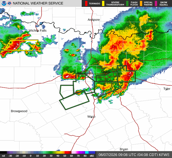
A severe Flood Watch is currently in effect for Sherman, Texas, issued by the National Weather Service in Fort Worth. This alert remains active until the afternoon of June 7, signaling a period where heavy rainfall may lead to flooding. Residents should remain vigilant as conditions evolve.

It is currently Sunday overnight, and the area is experiencing wet and windy weather. The air temperature stands at 70F, with a feels-like temperature of 72F. Humidity is extremely high at 96%, with a dew point of 69F. Winds are blowing from the south at 14 mph, with gusts reaching 21 mph. The sky is currently producing rain.

Forecast for Today and Tomorrow

The National Weather Service indicates that showers and thunderstorms are likely through the overnight hours, with cloudy skies and a low around 69F. South winds will ease to 5 to 10 mph, and new rainfall amounts between a quarter and half of an inch are possible.

Today, the chance of precipitation is 56%, with heavy rain expected. The high will reach near 80F, while the low drops to near 69F. Showers and thunderstorms are likely before 1pm, followed by a chance of showers and thunderstorms between 1pm and 4pm. Rainfall totals could range from a half to three quarters of an inch.

Tomorrow, conditions will shift significantly. The high will climb to near 88F, with a low near 75F. The chance of precipitation drops to just 2%, though thunderstorms remain a possibility. Heat index values are expected to reach as high as 97 during the night and 105 the following day. Winds will continue from the south at 10 to 15 mph, with gusts up to 25 mph.

Safety Reminders

With the active Flood Watch, please monitor local news for updates on rising water levels. Avoid driving through flooded roadways. As temperatures rise toward the 90s in the coming days, stay hydrated and limit prolonged outdoor exertion during the hottest parts of the day. Check on neighbors who may be vulnerable to extreme heat or flooding impacts.

National Weather Service radar for North Texas (KFWS)

Sources

https://radar.weather.gov

https://api.weather.gov

https://open-meteo.com

Share

Carmen Solis

Carmen Solis covers weather, the environment, and outdoor life around Sherman.

Related Stories